RECOMMENDATIONS ON COLLECTING GEOGRAPHICAL NAMES A Report Submitted To Survey Department INTRODUCTION Geographical names are proper names designating certain places or areas of the earth surface on land as well as water bodies. Perception of a terrestrial space and its features happen through names, which constitute their unmistakable identity. Names do not only serve for designating the single phenomenon or feature class, but also for the purpose of perception, recognition, distinction and communication. Names have decisive influence on the development of an identity. Names arouse expectations and convey prestige. Clear and consistent use of geographical names is important for surveying and mapping, postal services, telecommunication, health services, transportation, tourism, providing emergency services and in other areas of life. Non-uniform usage of geographical names leads to misunderstandings in many spheres of life. The cause of such m...
Posts
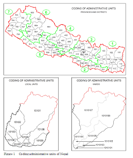
CODING THE ADMINISTRATIVE UNITS OF NEPAL FOR DATA INTEGRATION AND VISUALIZATION Published in Nepalese Journal on Geoinformatics Number 18, BS 2076 ABSTRACT The value of data increases by multifold if they are presented in spatial context. For the meaningful use of data, the data table and the spatial component, the map, should be processed and prepared in such a way that they can be integrated easily. Common identification code for data and map units (point, line or polygon) is the key to this integration. 1 INTRODUCTION For any development tasks to be formulated, scheduled, implemented and monitored, people need information. Nature is the ultimate source of all kinds of information. Almost all information is there with her, we just have to discover them for our needs. The information discovered should be passed to others so that they can use that information for the benefit...
TRANSLITERATION SYSTEM FOR NEPALI LANGUAGE Published in Nepalese Journal on Geoinformatics Number 11, BS 2069 Abstract: Maps are one of the most popular and comprehensive documents in which people can see geographical names and are one of the most effective means to convey accurate place names. In absence of these names it would be very hard to relate the map with the ground. It is very important to standardize these names to get rid of confusion, inconsistency, uncertainty and misunderstanding the names presented in a map. It is rational to develop a Romanization (Transliteration) System for Nepali, not only to support the initiatives of United Nations Group of Experts on Geographical Names (UNGEGN) but also to standardize the way the Nepali geographical names are written especially in maps. INTRODUCTION As the Surveyors and Photogrammetrists wrap up their data capturing works, it is time for Cartographers t...